
The Morrison Formation and its bounding strata on the western side of the Blanding basin, San Juan County, Utah
Abstract
In 2016 and 2017, the Utah Geological Survey partnered with the U.S. Bureau of Land Management to conduct a paleontological inventory of the Morrison Formation south and west of Blanding, Utah, along the eastern margin of the Bears Ears National Monument. The Morrison in this region is critical to understanding Upper Jurassic stratigraphy across the Colorado Plateau because it is the type area for the Bluff Sandstone, Recapture, Westwater Canyon, and Brushy Basin Members of the Morrison Formation, which are the basis for nomenclature in New Mexico and Arizona as well. Researchers have disagreed about nomenclature and correlation of these units, which transition northward in the study area into the Tidwell, Salt Wash, and Brushy Basin Members. Numerous vertebrate localities make inclusion of the Bluff Sandstone and Recapture Members in the Middle Jurassic San Rafael Group, as suggested by some previous workers, unlikely. The Salt Wash Member does not separate the Bluff Sandstone and Recapture Members at Recapture Wash, but sandstone lenses of Salt Wash facies occur higher in northern Recapture exposures. Northward, along the outcrop belt east of Comb Ridge, the Bluff-Recapture interval thins, interlenses, and pinches out into the Tidwell and lower Salt Wash, with the main lower sandstone interval of the Westwater Canyon merging northward into the upper Salt Wash Member.
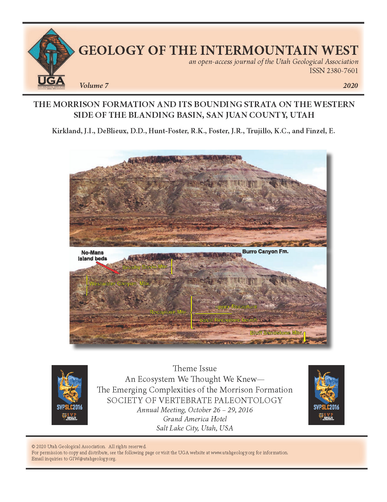
The partly covered, 1938 type section of the Brushy Basin Member is identified along Elk Mountain Road at the southern end of Brushy Basin. We describe a detailed, accessible Morrison Formation reference section about 11.2 km (7 mi) to the south along Butler Wash. There, 81.68 m (268 ft) of Brushy Basin Member is well exposed along a road between the top of the Westwater Canyon Member and the base of the Lower Cretaceous Burro Canyon Formation. We informally call the upper sandstone bed(s) of the Westwater Canyon Member that cap mesas and benches in the region “No-Mans Island beds.” Smectitic mudstones between the No-Mans Island beds and the main sandstone body of the Westwater Canyon suggest that the Salt Wash-Brushy Basin contact to the north may be somewhat older than the base of the Brushy Basin Member as originally defined in its type area. Determining whether the No-Mans Island beds pinch out to the north or are removed by erosion below the regional basal Brushy Basin paleosol requires further research. Several significant fossil vertebrate and plant sites have been documented in the Brushy Basin type area. Newly identified volcanic ashes provided zircons for U-Pb ages of 150.67 ± 0.32 Ma from near the top of the Brushy Basin Member and of 153.7 ± 2.1 Ma and 153.8 ± 2.2 Ma for two zircons in lower part of Recapture Member. At the top of the Brushy Basin Member, ferruginous paleosols commonly overlying conglomeratic sandstone are speculated to be of Early Cretaceous age (detrital zircon age pending) and are assigned herein to the Yellow Cat Member of the Burro Canyon Formation. These iron-rich paleosols suggest wetter climatic conditions during the Jurassic-Cretaceous transition in the Blanding basin.
Copyright (c) 2020 Geology of the Intermountain West

This work is licensed under a Creative Commons Attribution 4.0 International License.

